After thoroughly soaking in the hot springs, having lunch, and enduring the daytime heat lounging in the shade of trees, we arrived at the starting point of the next volcano route - Puyehue (2240) at 6 PM. The ascent to the summit involves nearly 2000 meters of elevation gain and a 10 km trail. We decided to split this ascent into two parts and spend the night in the mountains.
Starting point:
https://maps.app.goo.gl/AvZFQgdq1uRQioX5A
From the main road, you need to enter the private territory of a farm. The fee for the passage towards the volcano is 10000 - 15000 CLP per person. With this payment, you can use a hut halfway to the volcano's summit. The trail is well-marked and easy to follow.
At the bottom, you'll be greeted by the owner - a very pleasant young man who will gladly share all about the route and enjoy a chat.
The first part of the journey crosses the farm fields - walking on vivid green meadows with a view of mountains and well-kept cows and horses of all kinds around. We often recall Switzerland when trying to imagine the perfect mountain-rural landscape. But Chilean cows in the southern valleys are definitely cuter than Milka chocolate ads.
Then the trail goes into the forest, and the ascent begins. It was easy to walk in the shade of trees in the evening, and we set personal speed records. The best result was a 100-meter elevation gain in 8 minutes. Trail runners might laugh, but for a second trek of the day, it's quite good.
The forest ends with the ascent, revealing a view of a wide valley. After this, the climb continues towards the volcano's crater. The hut and a large camping meadow are in this valley. There's a stream nearby, so there are no water problems.
Refugio location:
https://maps.app.goo.gl/bskAKJ4dJkKYuB7b6
The timing was perfect - we had another hour of sunlight to set up camp, have dinner, and move on to stargazing under the black, civilization-free sky.
Waking up at dawn and having breakfast, we rushed to the volcano's summit. It wasn't as brisk as the previous day, but after 2 hours, we covered the remaining 900 meters of elevation gain and reached the crater.
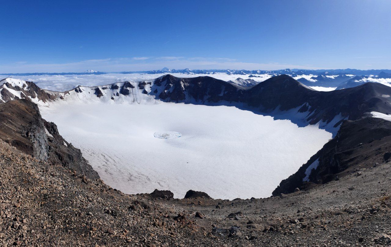
Puyehue's crater is a huge, almost perfectly circular valley, full of snow and ice. It leaves quite an impression. And the cracked ice in the center reminds us that this area is part of the Pacific Ring of Fire and is only conditionally dormant. The last major eruption happened here after the 1960 Valdivia earthquake, the most powerful recorded earthquake in history - 9.5 magnitude.
Here's a satellite photo of the smoking volcano in 2012: https://earthobservatory.nasa.gov/images/77065/puyehue-corda3n-caulle
Puyehue is right near the Argentine border, and the road leading to the trail goes to Bariloche. From the summit, you get a view of completely wild mountains. Streams of solidified black lava between lighter mountain slopes are clearly visible.
The weather added mystery to the surrounding landscape for us. All inhabited valleys were covered by a white ocean of clouds. It was impossible to imagine that just a few hours' walk away, there are cities, roads, and other people. A complete illusion that we are alone in these mountains amid the centuries-old silence of nature.
Starting point:
https://maps.app.goo.gl/AvZFQgdq1uRQioX5A
From the main road, you need to enter the private territory of a farm. The fee for the passage towards the volcano is 10000 - 15000 CLP per person. With this payment, you can use a hut halfway to the volcano's summit. The trail is well-marked and easy to follow.
At the bottom, you'll be greeted by the owner - a very pleasant young man who will gladly share all about the route and enjoy a chat.
The first part of the journey crosses the farm fields - walking on vivid green meadows with a view of mountains and well-kept cows and horses of all kinds around. We often recall Switzerland when trying to imagine the perfect mountain-rural landscape. But Chilean cows in the southern valleys are definitely cuter than Milka chocolate ads.
Then the trail goes into the forest, and the ascent begins. It was easy to walk in the shade of trees in the evening, and we set personal speed records. The best result was a 100-meter elevation gain in 8 minutes. Trail runners might laugh, but for a second trek of the day, it's quite good.
The forest ends with the ascent, revealing a view of a wide valley. After this, the climb continues towards the volcano's crater. The hut and a large camping meadow are in this valley. There's a stream nearby, so there are no water problems.
Refugio location:
https://maps.app.goo.gl/bskAKJ4dJkKYuB7b6
The timing was perfect - we had another hour of sunlight to set up camp, have dinner, and move on to stargazing under the black, civilization-free sky.
Waking up at dawn and having breakfast, we rushed to the volcano's summit. It wasn't as brisk as the previous day, but after 2 hours, we covered the remaining 900 meters of elevation gain and reached the crater.
Puyehue's crater is a huge, almost perfectly circular valley, full of snow and ice. It leaves quite an impression. And the cracked ice in the center reminds us that this area is part of the Pacific Ring of Fire and is only conditionally dormant. The last major eruption happened here after the 1960 Valdivia earthquake, the most powerful recorded earthquake in history - 9.5 magnitude.
Here's a satellite photo of the smoking volcano in 2012: https://earthobservatory.nasa.gov/images/77065/puyehue-corda3n-caulle
Puyehue is right near the Argentine border, and the road leading to the trail goes to Bariloche. From the summit, you get a view of completely wild mountains. Streams of solidified black lava between lighter mountain slopes are clearly visible.
The weather added mystery to the surrounding landscape for us. All inhabited valleys were covered by a white ocean of clouds. It was impossible to imagine that just a few hours' walk away, there are cities, roads, and other people. A complete illusion that we are alone in these mountains amid the centuries-old silence of nature.